

Wester Dod [Monynut Edge]
Good walks are even better shared.
Overview
Wester Dod [Monynut Edge]
Nestled within the Southern Uplands, Wester Dod rises to 400 meters, marking its presence as a Marilyn of modest height but significant charm. Its geological foundations, comprising primarily greywacke rock, present hikers a sturdy base to explore its grassy, rocky terrain with just a hint of bog now and then.
Routes
The Monynut Edge Trail is the most popular route, a delightful 5 km trek that can be comfortably traversed in around 2 hours. Starting at a small gravel pull-in near NT704681, this trail welcomes both seasoned walkers and energetic families. The terrain is moderately challenging – just enough to get the heart pumping but not to have you gasping for breath like you’ve just sprinted a marathon!
Summit Features
Upon reaching the summit, hikers are greeted with a charming cairn overlooking an enchanting panoramic vista. It’s a perfect spot for a quick Instagram shot (nature lovers will appreciate the background!) before heading back down or exploring the nearby hills.
Views
The view from the top is nothing short of spectacular. On a clear day, the Moffat Hills stand majestically in the distance, while lush green valleys stretch out below. Spring and autumn present the best opportunities for breathtaking scenery, as the changing leaves and flowers paint the landscape.
Hazards
As with any mountain, caution is key. The uneven terrain may be treacherous for those not watching their step, especially in damp conditions. Make sure your footwear is appropriate; the last thing you want is to swap your sturdy boots for squelchy, boggy slippers!
Access
Getting to Wester Dod is quite straightforward. A small parking area makes it easy to start your adventure without a lengthy trek from your car. Public transport is also accessible from the town of Moffat, but do check the schedules before heading out to avoid being left high and dry.
Facilities
Once you’ve conquered the heights, Moffat has your back with a range of cafes, pubs, and even toilets, ensuring you leave well-fed and with your dignity intact!
A Little History
The name 'Wester Dod' suggests historical depth, potentially tracing roots back to Old Norse, which makes it all the more intriguing. This area isn’t just about natural wonders; it also whispers stories of ancient settlers who once called this enchanting landscape home.
After your hike, share tales of your adventure with fellow romantics of the road, because who doesn’t love a good hiking story?
Happy hiking, and don’t forget to leave no trace!
Explore routes near Wester Dod [Monynut Edge]
Public walks starting within 80 km of this hill. Nearby does not mean a route reaches the summit; check its map and access before setting out.
Cockburnspath to Dunglass Dean and Old Bridge
View route
Duns Hen Poo Lake and St Mary’s Glade
View route
Coldingham Creel Path and St Abbs Bay
View route
St Abbs Head Lighthouse and Pettico Wick
View route
Route planning notes
These notes describe possible approaches, not verified navigable routes or permission to cross land. Check current paths, local access rules and conditions before setting out.
Monynut Edge Trail
A scenic trail starting from the nearest road, weaving through gentle hills and heathlands, ultimately leading to the summit.
Make a day of it, together
Find someone to share the walk with, or organise a day out along a route you like.
Photo Gallery
View all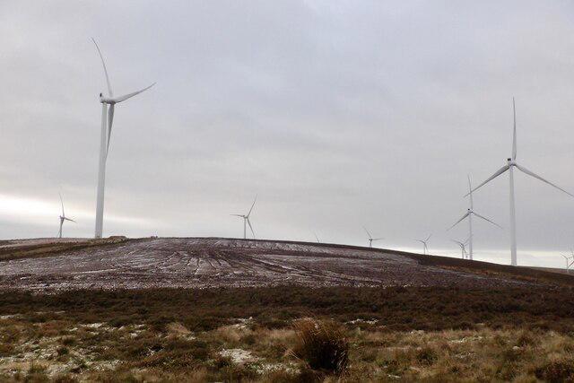 Photo could not load
NT7068 : Wind turbines, Monynut Edge
Richard Webb
Hill facts and local notes
Classifications
Elevation
416m
1,365 ft
Prominence
114m
Coordinates
55.9057, -2.4738
NT704681
OS Map
67
Explorer: 345E 351E
At the Summit
The summit is adorned with a prominent rocky outcrop and a modest cairn marking the high point, perfect for a quick selfie amidst the clouds.
Terrain & Geology
The composition is primarily of greywacke rock, typical of the Southern Uplands, providing a sturdy footing as well as some spectacular geological features including rocky outcrops.
Views & Scenery
Panoramic views of the surrounding hills and valleys, particularly of the Merse region and the imposing presence of the Moffat Hills in the distance.
History & Heritage
Name Origin
The name 'Wester Dod' likely derives from Old Norse, referring to a western hill or knoll.
Historical Significance
The area around Wester Dod has historical artefacts indicating settlement during both prehistoric and more recent times.
Getting There & Facilities
Check current local access restrictions, parking rules and transport timetables before travelling. These notes do not confirm public access to the summit.
Parking
A small gravel pull-in at NT704681 allows for easy access to the trailhead; suitable for two or three cars.
Public Transport
Buses run from Moffat, approximately 7 miles away; check local schedules for the latest updates.
Nearby Facilities
Moffat has several cafes, pubs and toilets, offering hot drinks and meals to refuel after your expedition.
Safety Information
Known Hazards
- Uneven terrain, potential for sudden weather changes, and the usual suspects such as slippery rocks in damp conditions.
General Safety Tips
- Check weather conditions before setting out
- Carry appropriate clothing and equipment
- Let someone know your planned route
- Take a map, compass, and GPS device
- Carry emergency supplies: food, water, first aid kit, torch
Hills
Some common questions about the hills answered
Are there group walks up Wester Dod [Monynut Edge]?
Many walkers use Walkmates to join or organise walks with others. You can check for group walks around Wester Dod [Monynut Edge] through the maps
Are there other walkers around Wester Dod [Monynut Edge]?
Activity varies by location and time, but Walkmates lets you see whether others have shared walks or shown interest in this area. Find other people through the walking friends search walking friends for Wester Dod [Monynut Edge] search or of course create your own walk for Wester Dod [Monynut Edge]
Can I organise a walk to Wester Dod [Monynut Edge]?
Yes. If there aren’t any walks listed already, you can create a walk and make it available for others to join.
If you're signed up to Walkmates, you can create a walk to Wester Dod [Monynut Edge].
How do I find a walk up this hill?
There are often multiple ways to walk this hill, depending on experience and route preference. Walkmates helps you explore walks and routes that others have shared.
Can I suggest a new route up Wester Dod [Monynut Edge]?
Yes. You can suggest or create routes to share with others. Walkmates focuses on the social side of walking, so routes are used to help people organise walks and explore areas together, rather than as detailed navigation tools or route libraries.
Other uses really appreciate knowledgeable walkers sharing their routes. Share your favourite route to Wester Dod [Monynut Edge] here
The is an error or something incorrect about this hill. How do I let you know?
We always strive to keep the information on Walkmates as accurate as possible. If you find an error, please let us know through the contact form and we'll aim to correct it as quickly as possible
Community Discussion
Comments
Location
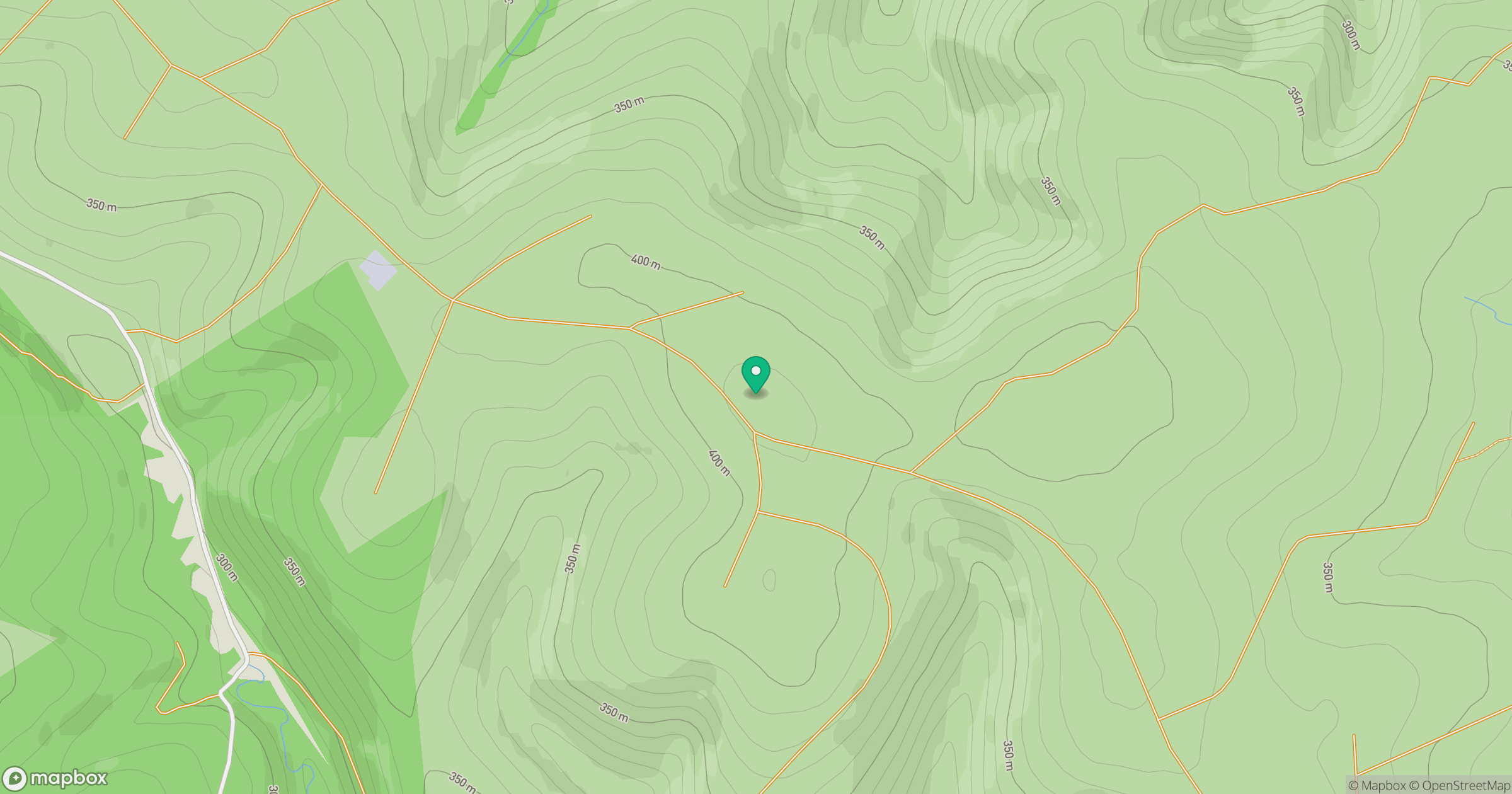
Grid reference: NT704681
View on OpenStreetMapOpens a map in a new tab, centred on the hill.
Hills within 30 km
Straight-line distance, not a walking route or confirmation of access.
No comments yet. Be the first.